Found artifacts and written historical records are used as archaeologists analyze landscapes. Working alongside the Department of Natural Resources, metal detecting, shovel testing and excavation are part of their work. The information described is sourced from Steven D. Smith’s book, Francis Marion and the Snow’s Island Community. It is important to remember that riverways have shifted and changed over time, adding a geographical twist to the exploration.
Smith, Steven D. 2021. Francis Marion and the Snow’s Island Community: Myth, History, and Archaeology. Asheville, N.C.: United Writers Press.
Terminology
Loyal to Great Britain were Loyalists & Tories.
Seeking independence were Patriots, Whigs and partisans.
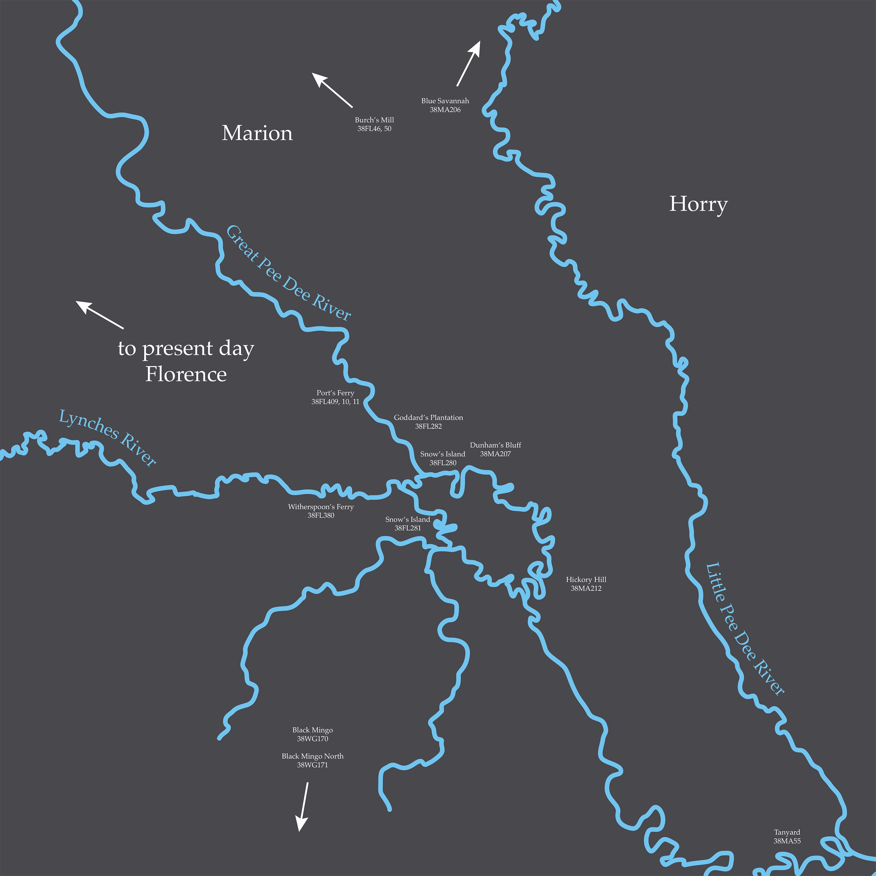
Site Descriptions (click to navigate)
Witherspoon’s Ferry (38FL380)
Port’s Ferry (38FL409, 38FL410, 38FL411)
Goddard’s Plantation (38FL282)
Snow’s Island (38FL280 and 38FL281)
Dunham’s (Dunnam’s) Bluff (38MA207)
Hickory Hill (38MA212)
Black Mingo (38WG170) and Black Mingo North (38WG171)
Blue Savannah (28MA206)
Burch’s (Burches) Mill (38FL46, 50)
Tanyard (38MA55)
Witherspoon’s Ferry (38FL380)
Noted in Mills’ Atlas (1825)
General Marion starts his independent partisan campaign here 17 August 1780 meeting the Williamsburg Militia
Port’s Ferry (38FL409, 38FL410, 38FL411)
General Marion conducted a redoubt on the east side of the Pee Dee in this area in September of 1780. A redoubt is military protection of territory or fortification. Through metal detecting, colonial period artifacts were found at these sites in 2006 and 2008 including musket side plates, buttons, a horseshoe, buckles, and hardware from architectural structures.
Goddard’s Plantation (38FL282)
In the 1990s, 358 metal objects were recovered including buttons, cuff links, thimbles, kettle fragments, rifle, and trade gun shot (non-military caliber), axe blades and hooks. This site was a colonial dwelling with structural footprints. Prehistoric artifacts and earthfast (i.e. no foundation) structures have been found here as well.
Historical records and on-site evidence point to this being the early colonial plantation of the Goddards. Archeological evidence of significant military presence is lacking at this point to sustain it being Marion’s main camp. One of the structural sites indicates a fire occurred here during the revolutionary era.
Snow’s Island (38FL280 and 38FL281)
Relic collectors have found colonial objects such as pewter spoons, glass, buttons and kettle fragments in this site. The site fits historical descriptions however artifact evidence is currently not strong enough to support it as a location of a partisan camp.
Dunham’s (Dunnam’s) Bluff (38MA207)
First partisan campsite examined by a professional archaeologist. Possible site of Snow’s Island Camp.
Mill’s Atlas map (1825) pinpoints it here and historical writing notes the camp as “on the east side of the Pee Dee”. This marks the camp as being east of modern Snow’s Island within this location.
Other historical writings support the theory that this could have been Marion’s main camp.
In 2007 items found include 216 metal objects, including lead, weapon fragments, metal clothing artifacts, a horse stirrup, a candle holder, and iron kettle fragments, 153 American and European ceramics, and ammunition evidence.
Hickory Hill (38MA212)
Late colonial domestic site (According to genealogist Phyllis Candy and Marion Biographer Robert D. Bass’s research, it is either the home of Daniel or Francis Britton or original location of Old Neck Chapel). Artifacts found here include a variety of ceramics, metal items such as buttons, nails, iron curry comb and a high ratio of buckshot and rifle balls. The number and type of military artifacts suggests that Partisan soldiers may have camped here.
Black Mingo (38WG170) and Black Mingo North (38WG171)
Nearby ferries, taverns were often located. Archeological evidence found here points to the location of Dollard’s Tavern and a portion of battlefield. This region allowed for supplies from Georgetown to arrive. Marion’s men camped in these lands. Evidence suggests campsites, not centered around domestic dwellings as well.
Blue Savannah (28MA206)
This site is concerned with locating battle and short skirmish sites. The Francis Marion Trail Commission searched in 2006 and 2007 for artifacts related to a battle which was instigated on rescuing a prisoner of the Loyalist militia by family members. Domestic site evidence was found along with a low number of shot.
Burch’s (Burches) Mill (38FL46, 50)
Burch’s plantation, ferry and mill are significant historical sites used by both British and American fighters. Francis Marion visited the site in 1781 and is known to have camped at the plantation, according to his records. Likewise, Colonel Doyle camped here after destroying Marion’s camp in 1781. Ganey and Marion signed their treaty establishing a truce to end fighting in this area, with both troops camping at the plantation.
Tanyard (38MA55)
W.W. Sellers writes this was the location of a Tanyard in the 1700s (a place where animals are tanned), run by the Michalls’ family.
Local tradition claims this was a site of a Marion camp and fortification, although no historical evidence exists. Various ceramic artifacts from the 18th century have been found here such as Chinese porcelain and Staffordshire slipware. A button from the 2nd South Carolina regiment (Marion’s regiment prior to the fall of Charleston) may or may not have been found here. The button’s story of discovery has shifted with time.